Understanding today's challenge

Accelerating tomorrow’s inland transport connectivity

UNECE promotes safe and sustainable transport by managing 61 UN legal instruments across roads, railways, waterways, and borders through its Inland Transport Committee and 21 specialized bodies, developing conventions, guidelines, and standards, and supporting their implementation with policy dialogue, technical assistance, and capacity-building to strengthen regional cooperation.

SITCIN Logo

#1

Fragmented Data and Connectivity Insights

To what extent does your country apply an integrated and data-driven approach to evaluating inland transport connectivity to support coordinated and effective decision-making?

SITCIN Logo

#2

Complex Border and Customs Procedures

How effectively are your country's customs procedures streamlined, harmonized, and aligned with international legal instruments to facilitate efficient cross-border movement of goods and reduce operational costs?

SITCIN Logo

#3

Limited Multimodal Integration

How well are transport modes integrated in your country to ensure seamless intermodal connectivity and smooth cross-border movement of goods?

SITCIN Cover

Turning Challenges into Opportunities

Sustainable Inland Transport Connectivity Indicators

SITCIN provides governments with a comprehensive, self-assessment-based, data-driven methodology for evaluating inland transport connectivity.
It builds on leading indices, including the World Bank Doing Business Indicators, the International Civil Aviation Organization (ICAO) Air Connectivity Index, and the International Maritime Organization (IMO) Liner Shipping Connectivity Index, to offer a standardized set of 215 indicators across road, rail, and inland waterways.

Section Separator

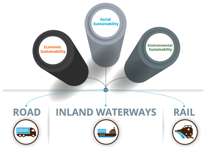
Three Pillars of Sustainability

This approach helps countries uncover performance gaps, enhance cross-border connectivity, and design evidence-based transport policies.
SITCIN goes beyond the user-focused Logistics Performance Index (LPI), which reflects the perceptions of shippers and freight forwarders, by offering a government-driven framework to assess actual performance and sustainability across inland transport systems.

Economic Sustainability

Indicators within this pillar aim at assessing and validating border crossing efficiency, time, and costs, as well as the quality of (inter-modal) transport infrastructure and the use of ICT and intelligenttransport solutions.


image

Social Sustainability

Indicators within this pillar aim at assessing the adequacy of road traffic rules enforcement, road traffic infrastructure, vehicle regulations and administrative frameworks surrounding cross-border transport of perishable foodstuffs and dangerous goods.

image

Environmental Sustainability

Indicators within this pillar have been designed to evaluate measures aimed at reducing greenhouse gas emissions, air pollutants and noise emissions. In doing so, they consider modal split, alternative fuel share, average age of fleet, etc.

image

Three Transport Modes

SITCIN aggregates measurable indicators across road, rail, inland waterways/intermodal transport within economic, social, and environmental pillars to provide governments with a universal self assessment tool to evaluate:

Economic Efficiency & Cost:

Customs clearance times, operational expenses, and transit costs.

Infrastructure & Intermodality:

Quality, design standards, and interconnectivity of transport networks.

Sustainable Development Goals

Digital Integration:

Deployment of advanced e‑solutions, data exchange platforms, and intelligent transport systems.

Social & Environmental Impact:

Safety protocols, regulatory harmonization, fleet maintenance, and emission controls.

SITCIN Cover

SITCIN Process

What are the steps involved to get you started?

The SITCIN process provides a structured pathway for countries seeking to evaluate and enhance their Inland transport connectivity. Designed for both government agencies and institutional stakeholders, the overall process comprises of registration and approval, preparation and account creation, data collection, data validation and publishing.

Registration and Approval

An official government institution submits the Expression of Interest form to UNECE, ESCWA, or ECLAC.

The responsible authority, usually the Ministry of Transport, appoints a National Focal Point (NFP) to coordinate Institutional Focal Points (IFPs) and lead national SITCIN data collection.

Depending on the country’s setup, IFPs may be drawn from agencies such as customs and border management, and ministries responsible for environment, health, infrastructure, trade, and economic development.

Once approved, the SITCIN Administrator creates the country profile on the SITCIN User Platform.

Expression of Interest contact form Step I

Preparation & Account Creation

Upon receiving instructions, the National Focal Point (NFP) will be invited to:

  • Proceed to complete the registration process on the SITCIN User platform;
  • Finalize My Country profile settings or request the SITCIN Administrator to update country specific information;
  • Create Institutional Focal Point (IFP) accounts and assign to each IFP specific clusters of indicators in accordance with their respective fields of competence and expertise.

Step II

Data Collection

Upon receiving access to assigned indicators, the Institutional Focal Point (IFP) will be invited to:

  • Begin the data collection and information gathering process;
  • Complete each indicator and send it for review to the National Focal Point (NFP); or
  • Return assigned but not answered indicators back to the NFP, in case the indicator goes beyond the IFP sphere of competence/responsibility.

The National Focal Point (NFP) will:

  • Reassign returned (i.e. not answered) indicators to new/other IFPs;
  • Review and approve completed indicators; or
  • Send indicators back to IFPs in case of inaccuracies.
Step III

Data Validation & Publishing

The National Focal Point (NFP) will:

  • Validate the information provided in response to each indicator;
  • Select which indicators and related information will be available for public access;
  • Prepare and attach an "Executive Summary".
  • Prepare and attach an "Action Plan".

Assessment is finalized and submitted to the SITCIN Administrator.

Step IV

National Connectivity Report (NCR)

Once the SITCIN Assessment is complete, the National Connectivity Report (NCR) will be automatically generated and published.

All the data, including the overall SITCIN score, will become accessible to other Government users, UN Regional Commissions and Multilateral Development Banks (MDBs), academic institutions and the wider public.

Access levels will vary among stakeholders, with accredited Government users and international organizations having access to more detailed data.

The Administrator validates the assessment, and the National Connectivity Report (NCR) is published.

Step V
SITCIN Cover

Assessment Status Map

SITCIN Pilot Country Assessments

The following summaries present the key findings of the SITCIN assessment in the five pilot countries. They highlight strengths and gaps in transport connectivity across infrastructure, border-crossing facilitation, digital solutions, regulatory frameworks, and environmental performance. Together, they provide a comparative snapshot of connectivity conditions in Georgia, Jordan, Kazakhstan, Paraguay, and Serbia.  

Strong political commitment to border facilitation, with 24/7 staffed and well-coordinated border points.
Advanced digitalization (eCustoms, eTIR, Single Window), though fleet management and electronic toll collection remain absent.
Maritime sector is well integrated into international agreements but is underfunded and vulnerable to regional instability.
Road infrastructure meets international standards, but weak regulatory frameworks deter investment.
Environmental performance is undermined by an aging truck fleet and weak enforcement of emission and noise standards.
Access SITCIN library
Strong framework for transporting dangerous goods and meat products, aligned with MERCOSUR standards.
Cross-border facilitation advanced (joint controls, e-solutions, temporary imports), but constrained by lack of 24/7 border operations and fast-track lanes for perishables.
Inland waterways outperform roads, supported by navigation rules and River Information Systems; more investment needed for year-round use and untapped rivers.
Environmental dimension weak, with an aging vehicle fleet and absence of emissions regulation or incentives.
Explore SITCIN library
Strong performer in road transport, with extensive international roads designed for speeds ≥100 km/h.
Border crossing points well equipped (parking, dedicated lanes for livestock/perishables, harmonized road classifications).
Inland waterways play a minor role; rail requires investment in overtaking tracks at border crossings.
Further improvements needed in facilitation, particularly round-the-clock border operations and joint control facilities with neighbours.
Discover SITCIN resources
Well-developed road network and inland waterways with good port capacity.
Rail infrastructure in poor condition with low operating speeds; no fully functional intermodal terminal.
Strong participation in international transport agreements; lowest customs clearance costs in the region.
Border efficiency needs improvement—simpler procedures, better coordination among agencies, and interconnected e-solutions.
Learn more at SITCIN library
Strong performance in cross-border facilitation, with electronic data exchange, free customs clearance for export and transit containers, and visa-free access for drivers from key trade partners. Greater coordination with neighboring countries, especially Azerbaijan and Armenia, is needed.
Road network scores well on coverage, dual carriageway length, and surface quality, but gaps remain in high-speed roads (≥100 km/h), service facilities, and tunnel management.
Rail infrastructure largely meets international standards through corridor participation, but outdated rolling stock, low speeds, and insufficient siding at border crossings limit efficiency.
Intermodal transport underdeveloped, with low shares of multimodal and containerized cargo despite alignment with global agreements.
Environment and energy dimension weakest, with old vehicles, lenient emissions legislation, and very limited use of alternative-fuel vehicles.
Visit SITCIN library

About UNECE's Role in Transport Facilitation

UNECE advances efficient, safe, and sustainable transport systems by servicing 61 UN inland transport legal instruments that cover road, rail, inland waterways, intermodal transport, and border-crossing facilitation. Through its Inland Transport Committee and 21 subsidiary bodies, it develops and updates international conventions, guidelines, and methodologies on transport planning, data, and standards, and supports their implementation through policy dialogue, technical assistance, and analytical work that strengthen regional cooperation and capacity-building. Building on this mandate, the SITCIN platform translates UNECE’s analytical and normative work into practice by offering a harmonized, data-driven tool that helps countries assess connectivity, identify bottlenecks, and enhance sustainable and interoperable transport networks across the region.

Our Story

Driving Sustainable Transport Connectivity

SITCIN is a pioneering, data-driven framework developed by the United Nations Economic Commission for Europe (UNECE), with the support of the United Nations Economic and Social Commission for Western Asia(ESCWA) and the Economic Commission for Latin America and the Caribbean (ECLAC). It is designed to strengthen national transport networks and enhance regional connectivity by providing countries with a structured approach to assess the performance, efficiency, and interconnectedness of their inland transport systems. This, in turn, informs evidence-based policy decisions and supports the achievement of transport-related Sustainable Development Goals (SDGs). Through interactive dashboards, real-time data visualizations, and detailed infographics, SITCIN simplifies complex connectivity metrics into clear, actionable insights—driving sustainable transport development at the national, regional, and global levels.

A Comprehensive Framework for Measuring Connectivity

SITCIN aggregates 215 measurable indicators across road, rail, inland waterways, and intermodal transport, providing governments with a universal self-assessment tool.

These indicators were developed through extensive field missions and policy dialogues in pilot countries—including Georgia, Kazakhstan, Serbia, Jordan, and Paraguay.

By aligning with international conventions (many under the purview of UNECE’s Inland Transport Committee), the United Nations Sustainable Development Goals (SDGs), and the Awaza Programme of Action for Landlocked Developing Countries (LLDCs) for the decade 2024–2034, SITCIN not only benchmarks current performance but also empowers policymakers to monitor and report progress toward sustainable development.

Although SITCIN is designed for use by all countries, it is especially valuable for Landlocked Developing Countries (LLDCs) — a group of 32 nations whose populations exceed 500 million. In 2019, the average GDP per capita in LLDCs was about US $1,625 (in constant 2010 dollars). These countries face severe structural constraints — and SITCIN helps by delivering a precise, data-driven diagnostic of transport connectivity gaps.

215+
Indicators
32
LLDCs Countries
533
million people
US$1,600
average GDP per capita

Transport connectivity gaps come with clear economic costs

Outdated infrastructure, poor regional integration, and lengthy border procedures can raise logistics and trade expenses by 30–100% compared to well-connected economies. Businesses face higher transport costs, customs fees, and storage charges, leading to increased consumer prices and fewer opportunities for growth in the logistics and trade sectors.

-0.5 to 1.0%
Slower annual GDP growth
20 to 50%
Higher logistics and transport costs
30 to 60%
Higher trade costs due to border delays
25 to 40%
Lower export volumes

Every additional border crossing can significantly raise costs and create instability in delivery times, resulting in up to 50–100% higher trade costs and 40% lower trade volumes, underscoring the importance of seamless connectivity between nations. (Read more at: UNCTAD – Transport Costs and Connectivity)

These challenges often translate into several percentage points of slower GDP growth, diminished foreign direct investment, and weakened resilience to climate or geopolitical shocks.

Countries that depend on overland routes or transit through other territories — rather than having direct seaport access — tend to face disproportionately higher logistical costs, greater delivery delays, and more trade barriers. In many landlocked economies, total transport costs are estimated to be 50–60 % higher than those of coastal counterparts.

Future Roadmap – What's Next for SITCIN

Our Future Roadmap outlines upcoming milestones, recent achievements, and planned enhancements for SITCIN.

Ongoing Pilot Projects:

Updates from countries implementing SITCIN include progress reports and success metrics.

Upcoming Features

Plans to integrate additional interactive dashboards, multilingual support, and advanced data visualizations.

New Partnerships

Announcements of collaboration with regional organizations, multilateral development banks, and academic institutions to expand SITCIN's reach and impact.

SITCIN Cover

Framework and Methodology

Comprehensive framework and technical approaches used in SITCIN assessment

SITCIN is unique because it builds on existing international frameworks, such as the World Bank's Doing Business and Logistics Performance Indexes, as well as complements indexes in aviation and maritime sectors, while offering a unified set of criteria to measure inland transport connectivity.

Robust Technical Framework:

SITCIN consolidates over 215 indicators into one comprehensive score across critical dimensions.

Data is collected through online surveys and then validated using interactive digital tools. The resulting weighted score provides a clear measure of a country's connectivity, supporting continuous monitoring and targeted improvements.

215+
Sub-Indicators
4
Critical Dimensions
"The SITCIN framework enables countries to identify strengths and weaknesses in their inland transport systems, supporting evidence-based policymaking and regional integration efforts"

Layered Weighting Methodology:

0.6
Road Weight
0.3
Rail Weight
0.1
Waterways Weight

Transport Mode Weights

Fixed baseline weights (e.g., 0.6 for road, 0.3 for rail, 0.1 for inland waterways) capture the relative importance of each mode in overall connectivity.

Indicator Cluster Weights

Each group of indicators is weighted according to its policy relevance and critical impact on sustainable transport performance.

Modal Share Adjustments/h4>

Scores are fine-tuned using real data on the share of freight movement by each mode.

Geographical & Financial Considerations

Adjustments account for countries’ natural constraints or budgetary limitations, ensuring fair and comparable evaluations.

 SITCIN Cover

SITCIN Assessment Demonstration

Experience how SITCIN works and the questions we ask

Select indicators, follow simple steps, and see how SITCIN evaluates connectivity.

  • Pandemic Resilience Indicators
  • Evaluate your transport infrastructure's preparedness for pandemic situations:
  • Essential protocols for managing pandemic situations at border crossings
  • Intelligent traffic management during emergencies
  • Redundancy of international road networks
  • Launch Demo
  • Comprehensive SITCIN Assessment
  • Original SITCIN Assessment Framework consisting of:
  • 3 Sustainability Pillars
  • 3 Transport Modes
  • 4 Clusters with set priority and weights
  • 215+ Indicators
  • Launch Demo
  • Climate Hazard Resilience Indicators
  • Evaluate your transport infrastructure's resilience to climate hazards, assessing and evaluating:
  • The preventive infrastructure and systems in place to reduce climate hazard impacts
  • The current condition of infrastructure and protection systems
  • Physical characteristics that affect resilience to climate hazards
  • Launch Demo